Perfect weather was forecast for Queens Birthday weekend, so I hatched a plan to visit the Wharfedale Hut with my wife Julia. We had both done separate tramps in the time since our last outing, so it was nice to be together this time. Wharfedale Hut offered an easy walk in, with the potential for a more adventurous return to the car if conditions were good.
The first sign of what was to await us came as we pulled into the carpark at the start of the Wharfedale Track. It seemed the superb weather forecast for the long weekend had driven everyone into the hills. As we laced up our boots and hoisted our packs I was trying to reason it through - some could be doing a day trip up Mt Oxford, others could be just going in to Ryde Falls, perhaps some are mountain biking the track and won't be staying overnight. The reality, as we were to discover later, was that most were in fact taking the same route as us...and in all likelihood they were all well ahead of us given our post-lunch departure.
Wharfedale Track was formed around the 1880's, when early settlers were seeking a new way to access Lees Valley, all of which had already been taken up by runholders. In those times access was via the Blowhard Track, a long and somewhat indirect route approached from Glentui. A quicker route was needed from Oxford, and so the Wharfedale Track was born.
Tramping the Wharfedale Track is a straightforward affair. The track is well formed and maintains an easy gradient as it winds its' way round the western flank of Mt Oxford, gaining height slowly and reaching its' high point at Wharfedale Saddle, standing at 750m. The saddle is not marked on the Topo50 map, and is at grid reference BW22 221152.
From here the track gently descends to a lower saddle at the head of Dobson Stream. There were numerous sections of eroded track between the two saddles, making the track quite narrow in places. Children who are capable of walking the track should manage these short sections without incident, but it may pay to keep them close just in case. At the saddle here the track branches, giving you the option of carrying on up the spur in front of you to Black Hill Hut, or turning right and heading down to Wharfedale Hut.
We made the turn and started the final leg of our journey to the hut. It would prove to be the most unpleasant part of the day, the track through here was very muddy in places, with significant storm damage across the track forcing us off-track and requiring some flexibility to move around or through the windfall. However it wasn't too long before we saw the welcome sight of smoke billowing from the hut chimney, a sight that quickened our pace to reach our home for the night.
It was soon apparent that there was a good crowd in for the night, and we weren't the last to arrive. In the end we had a cosy bunch of 19 squeezed in to the 8-bunk hut, four couples and a group of 11 Scouts. However in the true spirit of the New Zealand backcountry, everybody made way to accommodate the new arrivals. We were grateful for this as even though we had carried a tent just in case, the forecast was for a -4deg C night, so the hut was sure to provide a warmer night than being out in the tent!
And warm it most certainly was!!! With the fire roaring, 19 bodies, and the fact that none of the hut windows open, we were in fact far too hot to sleep so after an uncomfortable hour of trying, Julia and I decided to move to the floor. This paid off, the coolness of the floor giving immediate relief, and a much better night was had than some of those sleeping on the top bunk platform.
Morning dawned clear and very cold, a hard frost crunching underfoot. I had suggested an alternative route back to the car, suspecting that Julia, always one for adventure, might be a little uninspired by the wander back along the Wharfedale Track. This proved correct and so the plan was set, a return to the car by climbing up and over the western shoulder of Mt Oxford, with a side trip to bag the summit thrown in for good measure.
There is a track marked on the map that climbs a spur on the northern flank of the mountain and this was to be our route up, before descending via the well used track that follows another spur down to rejoin the Wharfedale Track not far from View Hill carpark. The only uncertainty in all of this was the condition of the track on the northern side of the mountain. While marked on the map, when I last spoke to DOC it wasn't one of their highly maintained tracks so given the storms of last winter and spring I was a little nervous that I might be leading Julia into a day of clambering over fallen trees. In our favour was the fact that the ranger I has spoken to indicated that they were hoping to clear this track over summer.
The track starts just behind Wharfedale Hut, and, optimistically in my opinion, indicates it's 2hrs 30mins to the summit of Mt Oxford. My feeling is that you would need to quite fit to achieve this, as the track up is just as long as the 2 tracks on the south side of the mountain, both of which are marked as taking 4hrs to the summit. Julia's not a big fan of travelling uphill, so I suggested it might take us 3hrs 30mins which would work out nicely to have lunch on the summit. She was happy so off we went.
It didn't take long for me to find the first sign of what I was looking for - evidence of chainsaw work clearing the track - and it soon became apparent that DOC had indeed been busy over summer. The track was in immaculate condition, with only one occasion where we had to climb over a tree lying across the track...thanks DOC!! Also, being north facing, the track itself was wonderfully dry underfoot which made for an easier climb.
Initially the track climbed steeply at a constant gradient until reaching the crest of the spur at Pt 945m. From here it became easier going as we followed the crest up and over Pt 975m (and back down the 80m drop after we passed the high point which was frustrating to give up the altitude), before making the final climb up to Pt 1130m, where we gained the ridge that would take us across to the summit of Mt Oxford. The turn off is signposted here, with the option of turning right to head down to View Hill, or left to make for Mt Oxford.
We pushed on, feeling like much of the hard work was now behind us, first dropping down to a saddle NE of Pt 1130m then climbing up through bush, with snow underfoot giving the bush a quiet stillness. We broke out of the bush at around the 1160m contour, sidling briefly on the bush-fringed northern side of the ridge before climbing up over a small tussock knob to a view of open tussocks leading across the tops to Mt Oxford's summit. I was hoping to crest this knob and find the summit immediately in front of us, but instead it loomed large in the distance, about 1.5km away over undulating tussock tops. We were close enough though for Julia to want to continue, the effort already put in demanding the reward of the summit, so off we went again, quickly crossing Pt 1300m then heading for the final 50m climb to the summit. It wasn't difficult at all and we made reasonably quick time, slowed only by the snow underfoot. It was extremely enjoyable tramping across the tops in glorious sunshine after being in the bush the entire tramp so far.
The final climb proved no problem, with the prospect of sitting down for lunch spurring us on, and we reached the summit at 2pm, having taken 4hrs 30mins from the hut. Like I said before, 2hrs 30mins seems a little optimistic even though we were not fast by any means.
A chilling wind met us at the summit so we hunkered down behind the well constructed stone wall on the summit and hastily ate lunch, took photos, and celebrated our achievement. It was a short lived stay, half an hour was enough, the wind and the time motivating us to get moving again.
We set off back the way we came, cutting a few corners on our way across the tops. Just before reaching the bushline Julia spied a bird soaring on updrafts and air currents which entertained her while I caught up - going downhill now meant it was her turn to be out in front.
We re-entered the bush, making our way back over Pt 1130m then along and over Pt 1124m before starting to drop down the spur to the carpark. It was easy going, but longer than we expected and with a lot more up and down travel than I was anticipating. Closer inspection of the map would have alerted us to this but I had glanced over it and figured it was a straight drop down to meet the Wharfedale Track. Not quite.
The light started to fade as we nearing the track junction, and it was here I made a mistake that left me on my back with a now bent walking pole under me. A simple slip, and a bit annoying coming so close to the end of our tramp.
The final section back along the Wharfedale Track to the carpark was a gentle stroll, guided by our headlamps with darkness drawing in, and we reached the car at 5.30pm having had a great weekend away together, and with the prize of the summit in our pockets.
 |
| Cup of tea while enjoying the sun on the Wharfedale Track |
 |
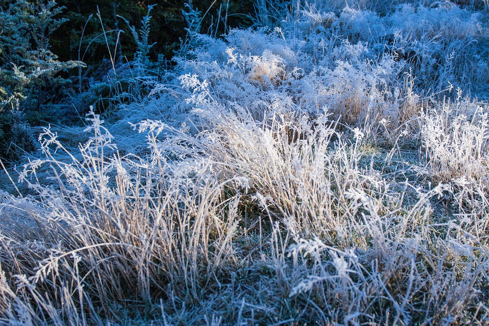
| Permanent frost alongside Dobson Stream, just behind Wharfedale Hut |
 |
| Permanent frost in Dobson Stream |
 |
| Wharfedale Hut |
 |
| Morning at Wharfedale Hut, with Black Hill in the background |
 |
| Ready to set off up to Mt Oxford - very cold!!! |
 |
| Frost outside Wharfedale Hut catching the first rays of sun |
 |
| On the final part of the climb to the ridgeline which we met at Pt 1130m |
 |
| On the final part of the climb to the ridgeline that would take us on to Mt Oxford |
 |
| Above the bushline, between Pt 1130m and Pt 1300m |
 |
| View across into Lees Valley |
 |
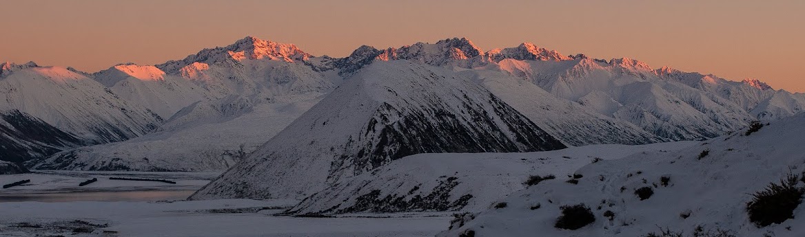
| Looking back along the ridge, Torlesse Range on the left, Black Hill far right |
 |
| Puketeraki Range, with its' highest point, Chest Peak (1936m), left of centre |
 |
| Julia crossing the tops towards Mt Oxford |
 |
| Summit in sight, but still a way to go before it's reached |
 |
| The final climb to the summit of Mt Oxford (1364m) |
 |
| Made it! - the summit of Mt Oxford |
 |
| Success |
 |
| View from the summit across the plains towards Christchurch, with Oxford at the foot of the hills |
 |
| View down to our hometown - Oxford |
 |
| Ready to get going again after a cold lunch |
 |
| Looking across the tops to Oxford Hill (1340m), and into Lees Valley |
 |
| The route back across the tops, Torlesse Range to the left, Craigieburn Range across the background |
 |
| Torlesse Range, viewed from the tops west of Mt Oxford |
 |
| First view of the summit - further away than I expected! |
 |
| Taking the direct line on our way back across the tops |
 |
| Looking up Shifton Stream towards Chest Peak |
 |
| Torlesse Range |
 |
| Julia watching a bird ride the air currents, our line of descent was along the bush clad spur in foreground |
 |
| Julia watching a bird ride the air currents, our line of descent was along the bush clad spur in foreground |
 |
| Looking down the spur we descended, Pt 1130m is the bump on the right |
 |
| Final view across to Ben More, Porters Pass, and Torlesse, with Hutt rear left |
 |
Crown Copyright - Land Information NZ
Access: Drive through Oxford, onto Depot Rd, then turn right onto Woodstock Rd, then right onto Ingrams Rd, then follow signposts to the View Hill carpark. The road passes through farm land and passes through 4 gates, leave as found.
Time: Carpark to Wharfedale Hut 5hrs, Wharfedale Hut to Pt 1130m 3hrs 30mins, Pt 1130m to Mt Oxford 1hr, Mt Oxford to carpark 3hrs
Map: BW22 Oxford
Hut: Wharfdeale Hut (8 bunks)
|
No comments:
Post a Comment